Property Record
691 W Whitehall St Sw, Atlanta, GA 30310
NEARBY LISTINGS FOR SALE OR LEASE
Property Detail
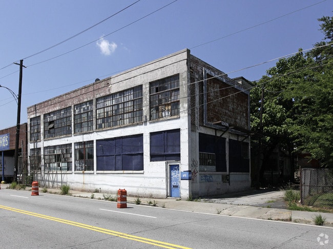
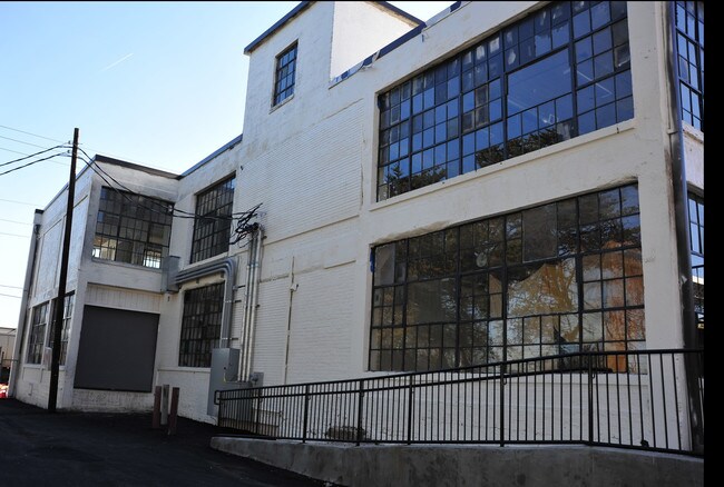
691 W Whitehall St Sw
Atlanta-Sandy Springs-Roswell, GA
Sl White Stag Llc & Old Republ
14-0107-0005-007-3
FC 7/22 EVENT HALL AND DESIGN SPACE
Warehouse
Fulton
X
Georgia
13121C0356F
228
2024
0.23 AC
2025
Central Atlanta
004200
Atlanta
14,012 SF
DEMOGRAPHICS near 691 W Whitehall St Sw
1 Mile
3 Mile
5 Mile
2024 Total Population
16,743
138,634
354,467
2029 Population
17,382
145,821
369,154
Pop Growth 2024-2029
+ 3.82%
+ 5.18%
+ 4.14%
Average Age
36
36
36
2024 Total Households
7,047
58,374
159,630
HH Growth 2024-2029
+ 4.00%
+ 5.70%
+ 4.34%
Median Household Inc
$35,980
$48,154
$66,020
Avg Household Size
2.00
2.00
2.00
2024 Avg HH Vehicles
1.00
1.00
1.00
Median Home Value
$318,850
$305,343
$358,181
Median Year Built
1983
1984
1984
Nearby Places
Map Layers
Map Styles
 Street
 Aerial
- Restaurants
- Banks
- Shops
- Fitness
- Groceries
PUBLIC TRANSPORTATION
TRANSIT/SUBWAY
West End (Gold Line - Metropolitan Atlanta Rapid Transit Authority (MARTA), Red Line - Metropolitan Atlanta Rapid Transit Authority (MARTA))
DRIVE
WALK
Distance
West End (Gold Line - Metropolitan Atlanta Rapid Transit Authority (MARTA), Red Line - Metropolitan Atlanta Rapid Transit Authority (MARTA))
1 min
5 min
0.3 mi
COMMUTER RAIL
Atlanta (Crescent - Amtrak)
DRIVE
WALK
Distance
Atlanta (Crescent - Amtrak)
11 min
5.6 mi
AIRPORT
Hartsfield - Jackson Atlanta International
DRIVE
WALK
Distance
Hartsfield - Jackson Atlanta International
15 min
9.4 mi
Freight Ports
Georgia Ports - Savannah
DRIVE
WALK
Distance
Georgia Ports - Savannah
278 min
248.7 mi
SALE & LEASE HISTORY
LISTING DATE
SALE/LEASE

Aug 28, 2019
For Lease
Apr 25, 2018
For Lease
Apr 23, 2018
For Lease
Nearby Properties
Address
Land Use
TOTAL SIZE
Lot Size
Zoning
Address
Land Use
TOTAL SIZE
Lot Size
Zoning
19.94 AC
SPI1
Address
Land Use
TOTAL SIZE
Lot Size
Zoning
1,585,451 SF
1.97 AC
SPI2
Address
Land Use
TOTAL SIZE
Lot Size
Zoning
11.74 AC
I1
Address
Land Use
TOTAL SIZE
Lot Size
Zoning
9.80 AC
C5
Address
Land Use
TOTAL SIZE
Lot Size
Zoning
3.16 AC
SPI1
Address
Land Use
TOTAL SIZE
Lot Size
Zoning
9 AC
C5
Address
Land Use
TOTAL SIZE
Lot Size
Zoning
10.27 AC
C5
Address
Land Use
TOTAL SIZE
Lot Size
Zoning
1,736,017 SF
3.63 AC
SPI2
Address
Land Use
TOTAL SIZE
Lot Size
Zoning
1,300,309 SF
4.81 AC
SPI1
Address
Land Use
TOTAL SIZE
Lot Size
Zoning
1,434,872 SF
1.89 AC
SPI1
Address
Land Use
TOTAL SIZE
Lot Size
Zoning
61.57 AC
C5
Address
Land Use
TOTAL SIZE
Lot Size
Zoning
10,954,869 SF
28.88 AC
C3
Address
Land Use
TOTAL SIZE
Lot Size
Zoning
1.55 AC
SPI1
Address
Land Use
TOTAL SIZE
Lot Size
Zoning
7 AC
C3
Address
Land Use
TOTAL SIZE
Lot Size
Zoning
1,314,183 SF
2.61 AC
SPI1
Address
Land Use
TOTAL SIZE
Lot Size
Zoning
2,577,342 SF
2.04 AC
SPI1
Address
Land Use
TOTAL SIZE
Lot Size
Zoning
13,340,229 SF
3.68 AC
SPI1
Address
Land Use
TOTAL SIZE
Lot Size
Zoning
1,589,465 SF
3.41 AC
SPI1
Address
Land Use
TOTAL SIZE
Lot Size
Zoning
2,971,832 SF
5.95 AC
SPI2
Address
Land Use
TOTAL SIZE
Lot Size
Zoning
3.62 AC
SPI1
Address
Land Use
TOTAL SIZE
Lot Size
Zoning
961,817 SF
25.44 AC
I2
Address
Land Use
TOTAL SIZE
Lot Size
Zoning
3,588,720 SF
1.32 AC
SPI1
Address
Land Use
TOTAL SIZE
Lot Size
Zoning
631,858 SF
1.33 AC
C5C
Address
Land Use
TOTAL SIZE
Lot Size
Zoning
766,925 SF
1.73 AC
SPI2
Address
Land Use
TOTAL SIZE
Lot Size
Zoning
1,975,400 SF
9.58 AC
RG4
Address
Land Use
TOTAL SIZE
Lot Size
Zoning
510,561 SF
87 SF
SPI1
Address
Land Use
TOTAL SIZE
Lot Size
Zoning
1.91 AC
I1
Address
Land Use
TOTAL SIZE
Lot Size
Zoning
34 AC
OI
Address
Land Use
TOTAL SIZE
Lot Size
Zoning
1,553,747 SF
2 AC
SPI1
Address
Land Use
TOTAL SIZE
Lot Size
Zoning
546,186 SF
0.68 AC
SPI2
The World's #1 Commercial Real Estate Marketplace
Connect with us
© 2025 CoStar Group
The information above has been obtained from sources believed reliable. While we do not doubt its accuracy we have not verified it and make no guarantee, warranty or representation about it. It is your responsibility to independently confirm its accuracy and completeness. Any projections, opinions, assumptions, or estimates used are for example only and do not represent the current or future performance of the property. The value of this transaction to you depends on tax and other factors which should be evaluated by your tax, financial, and legal advisors. You and your advisors should conduct a careful, independent investigation of the property to determine to your satisfaction the suitability of the property for your needs.